MapTiler ❤️ Open Source
We believe in the importance of open source components in geographical systems.
Join the community to build a better world.

The MapTiler Open Foundation
MapTiler is committed to distributing $100,000 to benefit the community.
The money will be distributed to the developers of open source projects (OSI approved licence), and to open data movements and organizations. This will enable them to carry on vital work such as maintenance and developing new features that benefit our customers.
By being our customer you support open-source!
Get in touch if you have an idea, or you would like to collaborate with us to bring high value to the open source community.
Projects we sponsor
MapLibre
MapTiler has been at the heart of MapLibre since its very beginning, as one of the main founders who laid the technical base and created the project’s first website.
We are now a proud sponsor, supporting the growth of fully open-source mapping libraries and SDKs for web and mobile applications.
Projects on GitHub we helped to start
OpenMapTiles
SQL, DockerOpen source maps made for self-hosting.
Free OpenStreetMap vector tiles for everybody.
www.openmaptiles.org GitHub: openmaptiles
EPSG.io
PythonSearch in a database of all spatial coordinate systems, accessible via API and user-friendly web interface.
www.epsg.io
GitHub: epsg.io
MapLibre GL JS
JavaScriptJavaScript library for displaying vector maps using WebGL. Fork of Mapbox GL JS.
www.maplibre.org
GitHub: maplibre-gl-js
MapLibre GL Native
C++, Java, Objective-C, KotlinMobile SDK for Android and iOS with Maps SDK for iOS and macOS. Fork of Mapbox GL Native.
www.maplibre.org
GitHub: maplibre-gl-native
TileServer-GL
Node.jsMap tile server based on node.js designed for serving and rasterizing OpenStreetMap vector tiles.
www.tileserver.org
GitHub: tileserver-gl
TileServer-PHP
PHPTiny map tile server designed for serving pre-generated raster and vector tiles with WMTS written in PHP.
GitHub: tileserver-php
WebGLEarth
JavaScriptAn open source virtual globe using WebGL with plug-and-play API compatibility with LeafletJS library.
www.webglearth.com
GitHub: webglearth2
OSMNames
SQL, PythonPlace names from OpenStreetMap. Downloadable. Ranked. With bbox and hierarchy. Ready for geocoding.
www.osmnames.org
GitHub: osmnames
Tiles a la Google Maps: globalmaptiles.py
Python script for utilities for conversion between tiles and coordinates.
GitHub: globalmaptiles.py
Flask-firebase
Google Firebase integration for Flask.
Open source ecosystem
Explore MapTiler's open-source tools and libraries, including web and mobile SDKs, API clients, and mapping utilities. Dive into the source code on GitHub and join our community in shaping the future of mapping.

Do you use our projects and find them helpful? Show your love ❤️ and post a tweet with a link and mention @maptiler. We are keen to promote your work!
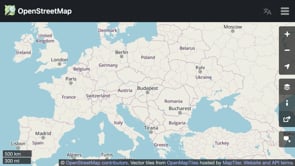
Vector layer for OpenStreetMap.org
To help mappers and the global OpenStreetMap community, we provide a vector map that serves as one of the map layers featured on openstreetmap.org.
The MapTiler OMT layer, built on the OpenMapTiles project, comes with an open-source style available on GitHub. It enables users to switch map labels into more than 80 languages.
Contributions to the FOSS community
MapTiler OMT style
MapTiler OMT is the official style of OpenMapTiles. It is open-source and its purpose is to display all features in vector tiles.

OpenLayers: Raster reprojection
Dynamic in-web-browser warping of raster layers to various map projections done by MapTiler team!

GDAL: GDAL2Tiles, GeoPDF
Essential open source data processing core has our code inside! Check the map tiling tool and PDFium.

OL-Cesium: 3D globe in OpenLayers
Synchronization of the view and raster layers between 2D OpenLayers and 3D Cesium globe.
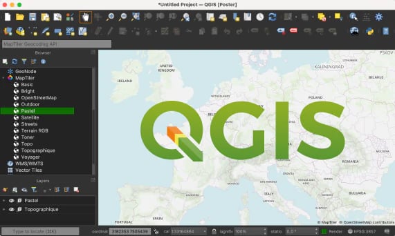
MapTiler QGIS plugin
Simply add basemaps to QGIS desktop from MapTiler Cloud. Customized OpenStreetMap base maps and satellite data ready to use.